The Central Valley region
San José, the Capital of Costa Rica offers many different attractions, though is usually use by tourist as a connecting point. Central Valley is where most costarricans live, includes the provinces of Cartago, Alajuela, Heredia and San Jose which are guarded by a ring of mountains and volcanoes.

National Theater of Costa Rica

This landmark was built between 1891 and 1897, modeled after the Paleis Garnier in Paris, France.
The mural inside the theater was painted by the Italian artist Aleardo Villa, which represents rural life in Costa Rica back when the museum was constructed. “Alegoría al Café y al Banano”, shows farmers harvesting coffee and bananas when this industry was at its peak. The inside is decorated with luxurious furniture, the vestibule floor has incrusted Carrara Marble and trimmed with bronze and gold. The theater also offers a gift shop and a cafeteria.
This archaeological Museum is home to the largest collection of American Jade in the world. Includes pieces dating back from 500 BC. It guards almost 7000 pieces of archaeological artifacts from pre-Columbian Jade to ceramics. Located in San Jose, Central Avenue, 13th street, walking distance from the National Theater.
Poas Volcano

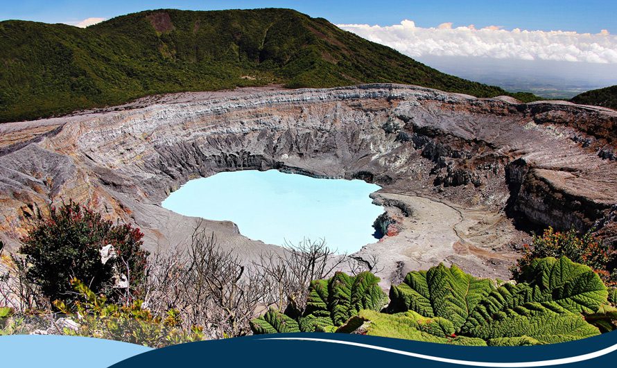
This active Volcano is a must visit when in Costa Rica, located in Alajuela makes it very easy for travelers to include it in their itineraries. It is one of costarican’s favorites for a one-day trip.
As you come along the curvy road, little by little you feel the change in the temperature as you get high up into the cloud forest.
Poas has one of the largest craters in the world, its main crater is circular shape and measures about 4330 feet (1320 m), 1049 feet (320 m) deep. Its edge is composed of pyroclastic materials such as blocks, bombs, ashes and 7540 years old lavas. It boasts a hot and acidic water lagoon with temperatures between 68 Fahrenheit (20° C) and 122 Fahrenheit (50 ° C).
The volcano has a history of eruptions where stands the one of 1910, which consisted of a huge cloud of ashes that rose to about 26.246 feet (8000 m). It last period of activity started in 2006. This National Park is one of the most important destinations for national and international tourism.
The Laguna Botos, an old crater occupied by a cold lake of 1312 feet (400 m) in diameter and 46 feet (4 deep). Its bottom is half-plane and sedimented by materials of the interior walls with the contribution of organic material.
(Currently closed, due to its most recent activity).
The area was called botos by the Spaniards, referring to a group of Indians who populated the foothills at Northside of the volcano. The term Póas can be derived from the Latin name "quills / púas" due to the presence of some spiny plants in the area or by the existence of a town called "Púas" located near the massif.
Also, this is probably one of the best areas to try some authentic Costa Rican cuisine. There are many little restaurants that offer the traditional “olla de carne”, Casado, picadillos and much more. In addition, this zone is well known for its coffee, so it may be a good idea to complement your visit to the volcano with a coffee tour.
Irazu Volcano

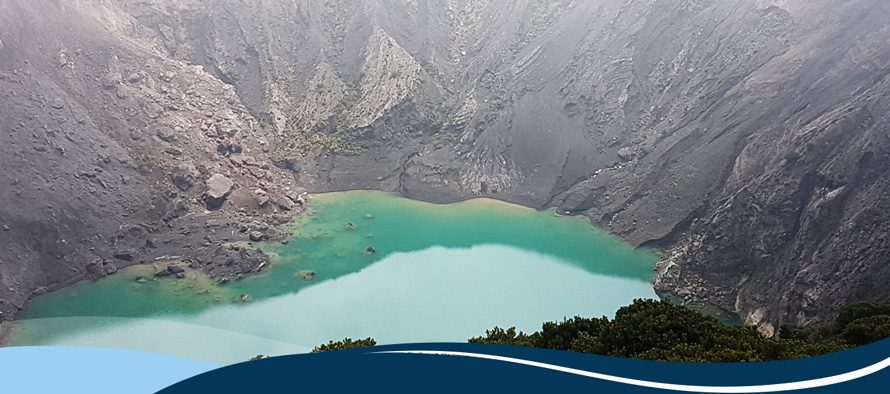
This is the highest volcano in Costa Rica. Located only 31 Km (19.2 miles), from Cartago city, it has five craters and astonishing views.
Its maximum elevation is 3432 m (11260 feet) above sea level, its average temperature goes from 5 to 9 ° C , (41 to 48,2 Fahrenheit), with a rainfall of 2387 mm (9.3 feet) in the Craters sector and 1527 mm (5.0 feet) annually in Prusian sector. It is a stratovolcano (distinct layers of volcanic material), with irregular subconical shape and five distinct craters.
The weather can be described as wet, cold and foggy, but if you are lucky, on a clear day, from its top you can see both Pacific and Atlantic Oceans, and with a telescope even the Lake of Nicaragua.
Within its protected area several rivers and streams born, giving rise to the basins of Reventazón, Sarapiqui, Sucio and Toro Amarillo Rivers. Also, due to its height and position in the Central Volcanic Range, Irazu Volcano is a strategic point for telecommunications in the country.
Braulio Carrillo National Park
Located in the Northside of Central Valley, among the massifs of the Poas and Irazu Volcanoes. It includes Barva and Cacho negro volcanoes. Its highest elevation on top of Barva Volcano is 9534 feet, (2906 m) above sea level, with records of a minimum temperature of 37.4 Fahrenheit (3 ° C.) and maximum 75.6 Fahrenheit (24 ° C.). This National treasure has one of the largest protected areas in Costa Rica, with the steepest topography of the country. Its land scape is mostly high mountains covered in forest and canyons where there are several rivers and streams of great importance nature wise as well as the production of hydroelectricity.
Most of Braulio Carrillo National park is covered with primary forests, there are about 6000 species of plants which represents half of all nationwide recorded species. There is a great diversity of fauna where it highlights the rich avifauna represented by 515 species of resident and migratory birds. This makes it an outstanding destination for birdwatchers, they stand out the king of vultures (Sarcoramphus papa), bell bird (Procnias tricarunculata), goldfinch (Myadestes melanops) and the remarkable quetzal (Pharomachrus mocinno).
Among mammal species stand white-faced monkeys (Cebus capuchinus), Colorado (Ateles geoffroyi) and Howler (Aullador, Alouatta palliata); tapir (Tapirus bairdii), puma (Puma concolor), jaguar (Panthera onca), peccary (Saino, Tayassu peccary), colmenero bear (Tamandua tetradactyla), mountain goat (Central American Red Brocket) and coyote (Canis latrans).


Turrialba Volcano

Located 24 Km (14.9 miles) northwest of the city of Turrialba, in the Cartago Province. This volcano forms a single system in conjunction with Irazú Volcano.
Its stratovolcano oval and its formation is due to explosive and effusive lava events. Turrialba volcano has three craters, on its slopes two cones were developed Cerro Tiendilla at 2971 m above sea level, (9747 feet), and Armado at 2750 m, (9022 feet), where there are found two living areas according to Holdridge classification: Forest Tropical Rainforest and Premontane very Humid Forest.
The average temperature is 16 ° C, (60 Fahrenheit) and average rainfall of 3000 to 4000 mm (9.8 feet to 13.1 feet).
The hike is worth the effort, especially when is clear, the view is simply magnificent, you can see the Caribbean plains, the Turrialba valley, view massifs of the National Parks Braulio Carrillo (as well as Barva Volcano and Cacho Negro), Póas Volcano and the highest peaks of the Talamanca Mountain range.
There are little restaurants in the area that offer a taste of the most traditional Costa Rican cuisine.
Orosi Valley

Less than an hour south from San Jose, the Orosi Valley offers a beautiful change of scenery with its rural vibe and its hot springs. This is a perfect one-day visit, but if you have time is worth taking advantage of the many cozy boutique hotels and restaurants around the area.
This coffee production area is surrounded by green mountains, fresh air and picturesque sites. Starting from a very simple but beautiful 1743 church, which is the oldest still in use in Costa Rica. Next to it, you will find the former Franciscan monastery, which is a museum exhibiting religious art and artifacts.
The town is famed for its natural hot springs, as well as its vistas, on a clear day you could even see the Irazú and Turrialba Volcano. A popular picture stop is by the Cachí hydroelectric dam, and a few kilometers from there you will find the village of Ujarrás, which is home of the ruins of Our Lady of Ujarrás. This is the earliest colonial church built in the country.
The story of how this church was built varies from source to source, but apparently the most popular version is that an indigenous fisherman brought a box containing a picture of virgin Mary to this site upon which it suddenly became immovable. Thinking this was a sign from heaven, an altar was built, and the church itself was completed in 1693.
Monumento Guayabo

Guayabo in Turrialba, was initially populated around 1000 BCE and then abandoned in 1400 CE, for reasons that are still a mystery. Researches, up to this day have not found a sign of why its inhabitants left. Some of their theories may suggest this was due to disease or rival civilizations.
This is believed to be the home of 10000 Pre-Columbian people. First discovered in the 1800s, and excavated for the first time 1882. Some of its findings include city's infrastructure, petroglyphs, tombs, and artifacts that were left behind and found by archaeologists in the 1960s during further excavations. The people of Guayabo were known to be well aware of good engineering, which can be assumed by their use of aqueducts.
What is supposed to be the central portion of this archeological site, consists of 43 stone foundations, dozens of smaller paths, two major roadways, three aqueducts, and some stone tombs. These society used to live in huge communal-like conical houses with thatched roofs with most of their family members.
Pacuare River

This river is famous for two things: its beauty and because is one of the best places in the world for whitewater rafting. Pacuare river offers rafting class III-IV, though rafting goes all year round, the best season is from October to December.
Right in the middle of a pristine jungle, the river opens through rugged canyons and tumbling cascades. Besides a good rush of adrenaline keep an eye opened to sight monkeys, sloths and all sorts of birds.

_Contact us_

+506 88413412

Secure Payment by credit card.
-Brand Image Design and Web design: “YAS MORA" ➜ okaymotion.com-


